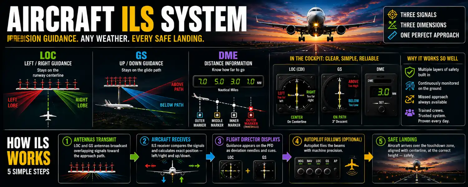
Fog so thick the wingtips disappear. Rain hammering the windshield at night. And somewhere ahead, invisible, a runway — which the aircraft finds anyway, arriving on the centerline at exactly the right height, every time.
They follow the Instrument Landing System (ILS) — a precision radio system that projects an invisible highway in the sky, guiding aircraft to the runway in fog, heavy rain, low cloud, and darkness. Two radio beams define the path — one for direction, one for descent — and the aircraft simply keeps itself centered on both, all the way down.
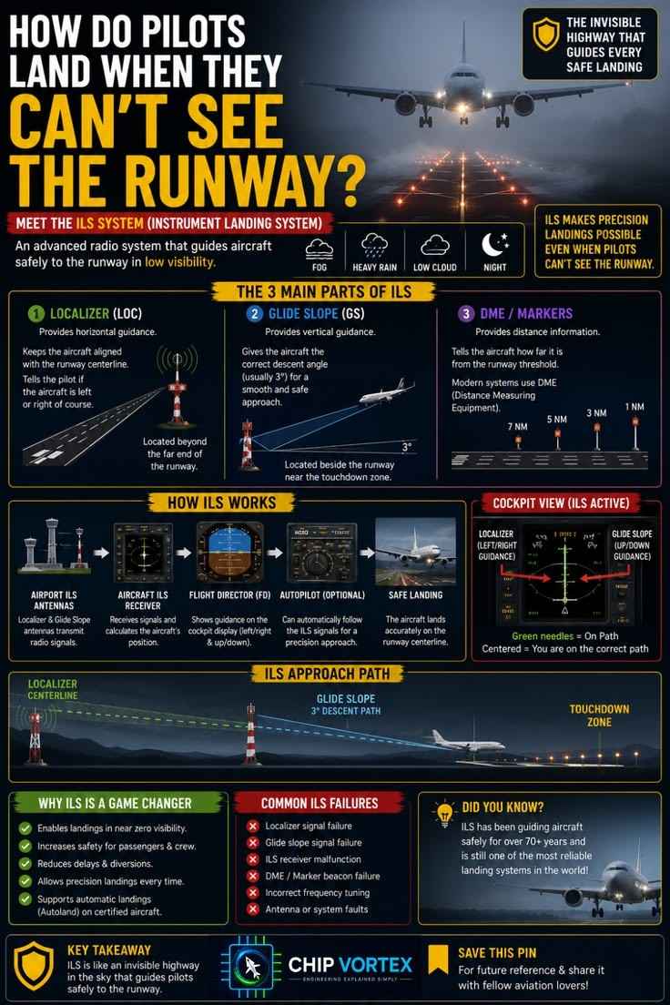
Save the chart for revision, then let’s walk the invisible highway from its transmitters to the touchdown zone.
🔧 Try It Yourself: Interactive ILS Simulator
The 3 Main Parts of ILS
1. Localizer (LOC) — Horizontal Guidance
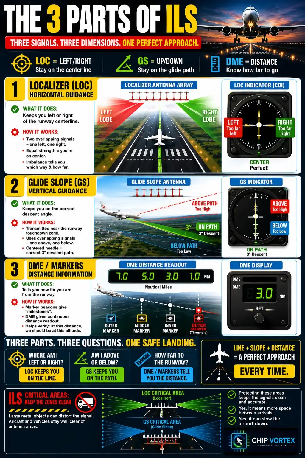
The localizer answers one question continuously: are you on the runway centerline? Its antenna array sits beyond the far end of the runway, broadcasting two overlapping radio signals — one favoring the left side of the approach, one the right. The aircraft’s receiver compares them: equal strength means you’re on the extended centerline; any imbalance tells you exactly which way you’ve drifted and how far. The result in the cockpit is beautifully simple — a needle that says left, right, or perfect.
2. Glide Slope (GS) — Vertical Guidance
The glide slope does the same trick vertically. Transmitting from beside the runway near the touchdown zone, it defines a descent path — usually 3 degrees — using the same overlapping-signal principle, one lobe above the path and one below. Centered needle: you’re descending on the correct angle. One expert wrinkle every pilot learns: the antenna’s radiation pattern creates false glide slopes at steeper angles above the real one — which is exactly why crews always intercept the glide slope from below, guaranteeing the first path they capture is the true 3°.
3. DME / Markers — Distance Information
Direction and descent angle still leave one question: how far to the runway? Historically, marker beacons answered it — radio “milestones” under the approach that beeped as you crossed them. Modern installations pair the ILS with DME instead, giving a continuous distance readout to the threshold — 7 miles, 5, 3, 1 — so the crew can cross-check the whole approach: at this distance, we should be at this altitude. Three parts, three dimensions: line, slope, and distance.
How ILS Works: 5 Steps
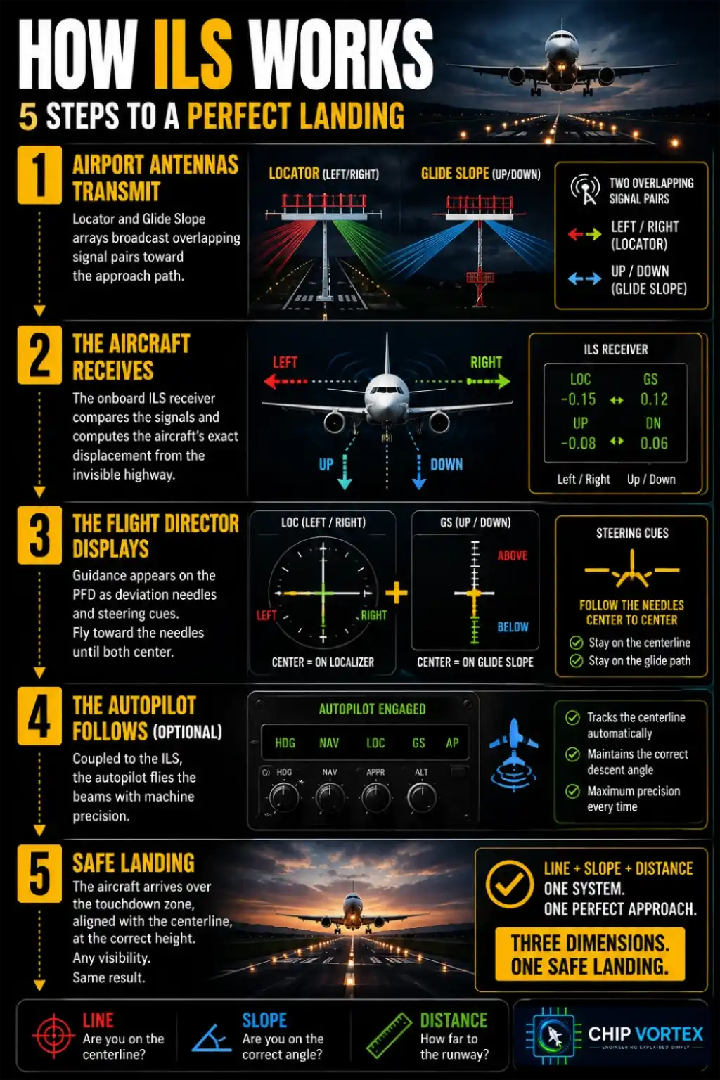
Step 1 — Airport antennas transmit. The localizer and glide slope arrays broadcast their overlapping signal pairs toward the approach path.
Step 2 — The aircraft receives. The onboard ILS receiver compares the signals and computes the aircraft’s exact displacement from the invisible highway — left/right and up/down.
Step 3 — The flight director displays. Guidance appears on the PFD as deviation needles and steering cues: fly toward the needles until both center.
Step 4 — The autopilot follows (optional). Coupled to the ILS, the autopilot flies the beams with machine precision — the basis of every low-visibility precision approach.
Step 5 — Safe landing. The aircraft arrives over the touchdown zone, aligned with the centerline, at the correct height — whether the pilots saw the runway ten miles out or ten seconds out.
Reading the Needles
The cockpit presentation is the same on a light trainer and an airliner: a localizer needle for left/right, a glide slope needle for up/down. Needles centered — as the pin says, you are on the correct path. The discipline is chasing neither: small, early corrections keep the needles alive and centered, and an approach flown well looks almost boring. That’s the goal.
CAT I, II, III: How Low Can You Go?
Not all ILS approaches are equal — they come in categories, and each category is a license to descend lower before deciding. The key concept is decision height: the altitude at which the crew must see the runway environment — or immediately go around.
CAT I brings you to a decision height of about 200 feet. CAT II, with better ground equipment, aircraft certification, and crew training, lowers it to about 100 feet. CAT III is the near-zero-visibility league: decision heights below 100 feet or none at all, with CAT IIIb permitting operations in visibility of just tens of meters — this is autoland territory, where the autopilot flies the approach, the flare, and even tracks the centerline on rollout while the crew monitors every parameter. (CAT IIIc — true zero-zero — exists on paper but isn’t used operationally; even a perfectly landed aircraft still has to find its way to the gate.) Each step down the ladder costs more equipment, more training, and more protection on the ground — which brings us to fog delays.
Why ILS Is a Game Changer
It enables landings in near-zero visibility, raises safety for everyone aboard, slashes weather diversions and delays, and delivers precision on every single approach — plus automatic landings on certified aircraft. Before ILS, low cloud simply closed aviation down. After it, the weather mostly just watches.
Common Failures — and Why the System Stays Safe
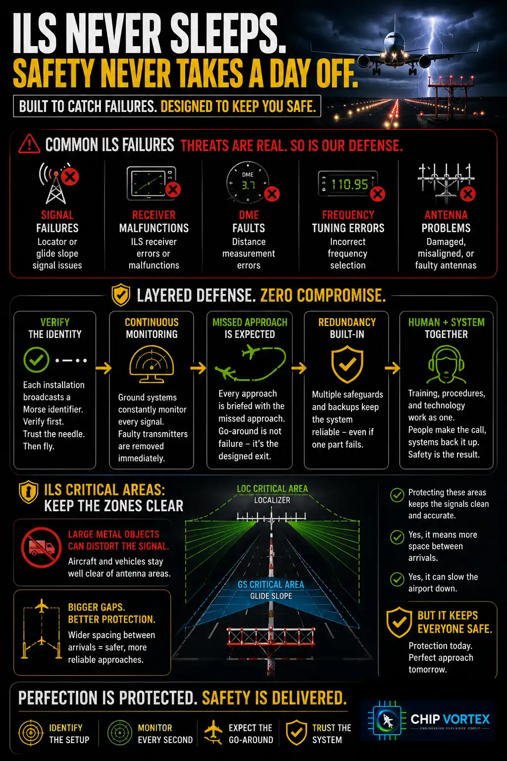
The pin’s failure list is real: localizer or glide slope signal failures, receiver malfunctions, DME faults, incorrect frequency tuning, antenna problems. What keeps them from becoming accidents is a layered defense. Crews verify the ILS identity — each installation broadcasts a Morse identifier, confirming the right frequency is tuned before trusting a single needle. Continuous monitoring on the ground automatically takes a faulty transmitter off the air rather than let it lie. Every approach is flown with the missed approach already briefed — the go-around isn’t a failure, it’s the designed exit, available at any second.
And one protection most passengers never hear about: ILS critical areas. In low-visibility operations, taxiing aircraft and vehicles are held well clear of zones near the antennas, because a large metal object between the localizer and an arriving aircraft can bend the signal. Protecting those areas means bigger gaps between arrivals — which is the honest answer to a very common question: even with ILS, fog still slows the airport down. The system isn’t the bottleneck; protecting its perfection is.
Did You Know?
ILS has been guiding aircraft safely for over 70 years — one of the longest-serving, most trusted systems in aviation. Satellite-based precision approaches are gradually joining it, but the invisible radio highway remains the worldwide standard it has been for generations: proof that when something works this well, aviation keeps it.
FAQ: Instrument Landing System
Can planes really land in zero visibility?▾
Very nearly. CAT IIIb operations permit autoland in visibility of just tens of meters — the autopilot flies the approach and touchdown while the crew monitors. True zero-zero (CAT IIIc) isn’t used operationally, because the aircraft still needs to taxi.
What does “established on the ILS” mean?▾
Both needles captured — the aircraft is tracking the localizer (centerline) and the glide slope (descent path), locked onto the invisible highway for the final approach.
Why do pilots intercept the glide slope from below?▾
Because the antenna pattern creates false glide slopes at steeper angles above the real one. Approaching from below guarantees the first slope captured is the true 3° path.
What happens if the ILS fails during an approach?▾
The crew goes around — the missed approach is briefed before every landing and available at any moment. They then try again, switch to another approach type, or divert. Ground monitoring also removes faulty signals from the air automatically.
If ILS exists, why do flights still get delayed in fog?▾
Capacity, not capability. Low-visibility operations require protecting the ILS critical areas and increasing spacing between arrivals, so the airport lands fewer aircraft per hour — everyone gets down safely, just not as quickly.
Next foggy arrival, you’ll know exactly what’s guiding you — two crossed needles and seventy years of trust. Which surprised you more: false glide slopes or the real reason for fog delays? Tell us in the comments. Save the chart, and follow the highway back through the series: the Navigation System (where ILS fits among its five siblings) and Inside the Cockpit (where those needles live).