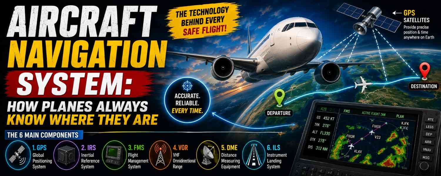
Somewhere over the ocean tonight, an airliner will be tracking its position to within meters — with no roads below, no landmarks in sight, and nothing outside the window but black. That’s the everyday miracle of the aircraft navigation system.
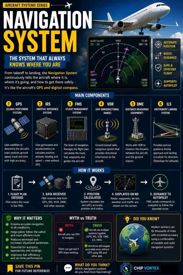
From takeoff to landing, the navigation system continuously tells the aircraft where it is, where it’s going, and how to get there safely. Think of it as the aircraft’s GPS and digital compass combined — except it’s actually six systems working together, cross-checking each other every second of the flight.
Save the chart for revision, then let’s meet each of the six.
🔧 Try It Yourself: Interactive Navigation Simulator
What the Navigation System Actually Delivers
Four things, constantly: an accurate position (where exactly are we?), route guidance (are we on the planned path?), a safe and efficient flight (the best track around weather, terrain, and traffic), and the data feed that supports the autopilot so the aircraft can fly that path precisely. Every component below exists to serve one or more of those four jobs.
The 6 Main Components of Aircraft Navigation
1. GPS (Global Positioning System)
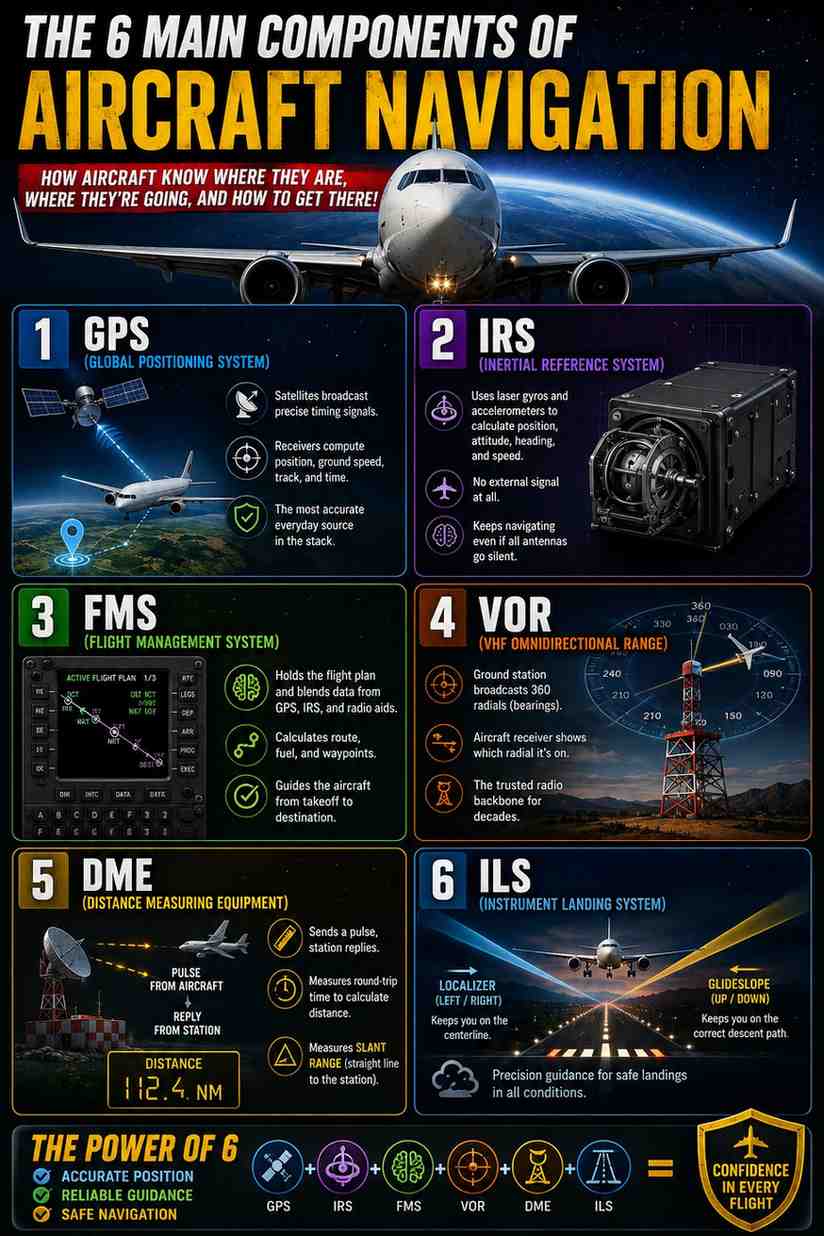
The famous one. A constellation of satellites broadcasts precise timing signals; the aircraft’s receivers compare those signals to compute position, ground speed, track, and time with remarkable accuracy. Aviation-grade receivers go a step further than your phone — they continuously monitor the integrity of the satellite signals, so the system knows not just where it thinks it is, but how much that answer can be trusted. GPS is the most accurate everyday source in the stack — but as we’ll see, it is deliberately never the only one.
2. IRS (Inertial Reference System)
The most fascinating box on the aircraft. The IRS uses laser gyroscopes and accelerometers to calculate position, attitude, heading, and speed — with no external signal at all. Before departure it performs a quiet party trick: sitting still at the gate, it senses the rotation of the Earth itself to work out which way is true north. From that moment on, it measures every acceleration and turn the aircraft makes and dead-reckons its position continuously. A pure inertial solution drifts slowly over the hours — which is exactly why it’s blended with GPS and radio aids — but if every antenna on the aircraft went silent, the IRS would keep navigating from memory and physics alone.
3. FMS (Flight Management System)
The brain of navigation. The FMS holds the flight plan, blends the position data flowing in from GPS, IRS, and radio aids, calculates the route, fuel, and waypoints, and guides the aircraft along the plan. It’s the component that turns raw position into decisions — and it’s important enough that we’ve given it a full deep dive of its own: What Is FMS? Flight Management System Explained.
4. VOR (VHF Omnidirectional Range)
The classic ground-based radio aid. A VOR station broadcasts 360 individual bearings — called radials — like spokes from a hub, and the aircraft’s receiver identifies which radial it’s on, giving the pilot a direction to or from the station. For decades, the world’s airways were literally drawn from VOR to VOR — highways in the sky with radio beacons as the junctions. GPS has taken over daily routing, but the VOR network remains the trusted radio backbone underneath it.
5. DME (Distance Measuring Equipment)
VOR’s partner, usually installed at the same site. The aircraft interrogates the DME station with a radio pulse; the station replies; the equipment times the round trip and converts it to distance. Combine a VOR bearing with a DME distance and you’ve fixed your position with radio alone. One classic detail: DME measures slant range — the straight line to the station — so an aircraft directly overhead at 36,000 feet reads about 6 miles, not zero. It’s measuring the hypotenuse.
6. ILS (Instrument Landing System)
The precision specialist for the last few miles. An ILS projects two radio beams from the runway: the localizer, which marks the extended centerline (direction), and the glideslope, which defines the correct descent path down to the threshold (altitude). Fly both needles centered and the aircraft arrives at the runway in exactly the right place at exactly the right height — in cloud, at night, in weather that hides the runway until the final moments. On suitably equipped aircraft with trained crews, the highest ILS categories even allow the autopilot to land the aircraft automatically while the pilots monitor.
How It All Works: 5 Steps
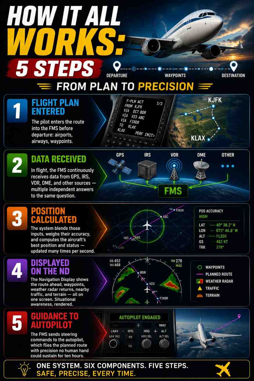
Step 1 — Flight plan entered. The pilot enters the route into the FMS before departure: airports, airways, waypoints.
Step 2 — Data received. In flight, the FMS continuously receives data from GPS, IRS, VOR, DME, and other sources — multiple independent answers to the same question.
Step 3 — Position calculated. The system blends those inputs, weighs their accuracy, and computes the aircraft’s best position and status — updated many times per second.
Step 4 — Displayed on the ND. The Navigation Display paints the picture for the crew: the route ahead, waypoints, weather radar returns, nearby traffic, and terrain, all on one screen. Situational awareness, rendered.
Step 5 — Guidance to autopilot. The FMS sends steering commands to the autopilot, which flies the planned route with a precision no human hand could sustain for ten hours.
Why It Matters
Accurate navigation in all conditions is the foundation everything else stands on. It lets pilots follow the safest and most efficient route, cuts crew workload while raising situational awareness, and makes modern autopilot flying, instrument approaches, and low-visibility landings possible at all. It even shows up on your ticket: precise navigation means direct routes, optimal profiles, better fuel efficiency, and on-time arrivals. When navigation is exact, everything downstream gets better.
Myth vs Truth
Myth: aircraft only use GPS to navigate. Truth: airliners use multiple systems together — GPS, IRS, VOR, DME, ILS, all fused by the FMS. GPS is one voice in a choir, deliberately cross-checked against sources that fail in completely different ways.
Myth: pilots can get lost if GPS stops working. Truth: the aircraft keeps navigating accurately without it. The IRS needs no signal at all, and the VOR/DME network provides radio positioning exactly as it did for decades before GPS existed. This layered design has real-world weight today — GPS interference and jamming are genuine issues in some parts of the world, and aircraft transit those regions safely precisely because navigation was never built on a single system.
Did You Know?
Modern airliners fly thousands of miles — including entire ocean crossings far beyond any ground station — with incredible accuracy, by combining satellite navigation with inertial reference and radio aids. Over the middle of the Pacific, it’s the IRS and GPS quietly agreeing with each other that carry the aircraft to a runway on the far side of the planet.
FAQ: Aircraft Navigation System
Do planes really only use GPS?▾
No. GPS is one of several sources. The FMS blends GPS with inertial (IRS) and radio (VOR/DME) data, cross-checking them continuously so no single failure can mislead the aircraft.
What happens if GPS fails or is jammed?▾
The aircraft keeps navigating. The IRS dead-reckons with no external signal, and VOR/DME stations provide radio position fixes. The crew may lose some precision, never the picture.
What’s the difference between VOR and DME?▾
VOR tells you direction — which radial from the station you’re on. DME tells you distance — how far from the station you are. Together they fix your position.
Can a plane land automatically using ILS?▾
Yes — on suitably equipped aircraft with trained crews, the highest ILS categories permit an automatic landing in very low visibility, with the pilots monitoring the system throughout.
How can the IRS navigate without any signal?▾
It measures every acceleration and rotation of the aircraft with gyroscopes and accelerometers, starting from a known point — and it finds true north before departure by sensing the Earth’s own rotation while parked at the gate.
Which navigation system do you find most fascinating — the satellite, the laser-gyro box, or the radio beams? Tell us in the comments. Save the chart to your aviation board for revision, and continue the Aircraft Systems Series with our deep dive into the Flight Management System.